BANDA VEJA AND BANDA SOULÌA: DISCOVERING THE VILLAGES OF THE CERVO VALLEY
Trail marker:
GTB - dedicated signage
Place of departure:
Parco delle Cave
Place of arrival:
San Giovanni Sanctuary
Departure altitude:
699 m
Arrival altitude:
1018 m
Duration:
6 hours - it is recommended to cover the itinerary in two days, staying overnight at San Giovanni Sanctuary
Uphill height difference:
300 m
Type of excursion:
Trekking
Season:
Winter, Spring, Late spring/summer, Autumn
Discover some of the most beautiful villages in the Cervo Valley, discovering their history, nature and hidden treasures
Access and parking
From Biella go up the Cervo Valley along the SP 100 for about 10 km. Shortly after passing Fucina and Balma, a bridge on the left crosses the Cervo stream. Immediately past the bridge, there is a cafeteria and an open car parking space.
Route
The path joins almost all the hamlets of the three municipalities of the Cervo Valley: San Paolo Cervo, Campiglia Cervo and Quittengo. An average trained hiker can walk it in a day since it does not present particular difficulties. However, it is advisable to walk it in two stages, spending the night at the Sanctuary of San Giovanni. In this way, it will be possible to immerse oneself more in the tranquillity of the valley.
Bande Veja and Banda Soulia are the names of the two sides (Banda) of the valley that flow into the Cervo stream. The shadier part (Veja) corresponds to the municipalities of San Paolo Cervo and Campiglia Cervo, the sunnier part (Soulia) to the municipalities of Campiglia Cervo and Quittengo.
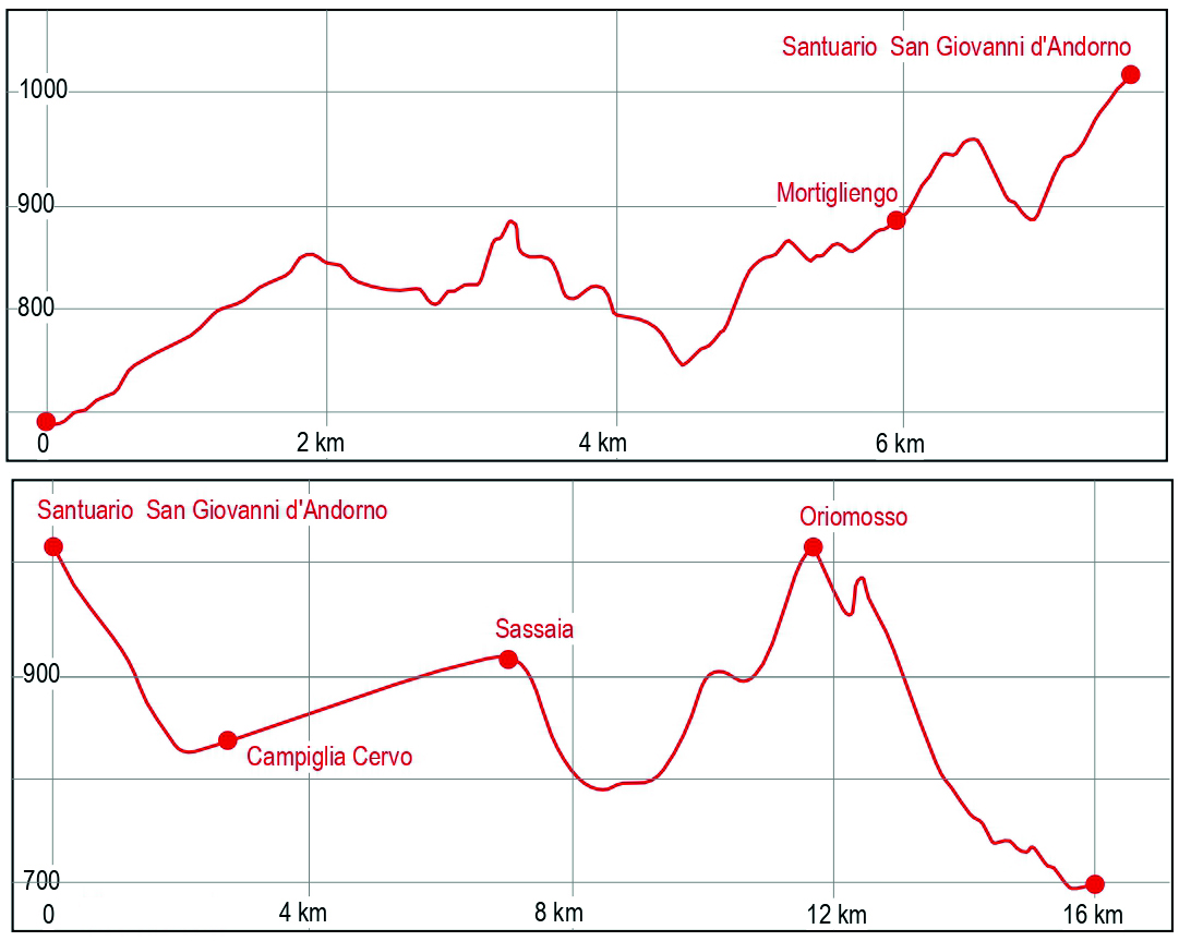
1st stage
Park the car and head along the tarmac road that climbs up, past the bar, towards Riabella. From here, head towards the Parco degli Arbo and Belvedere del Massaro; there are GTB signs. Passing the panoramic viewpoint of Belvedere del Massaro, you soon reach San Paolo Cervo village, which you cross. Follow the GTB signs, cross the Rivazza stream and, without any possibility of error, you reach the village of Mortigliengo. Here there are no GTB signs and so climb towards Mazzucchetti hamlet. Now continue along a path leading to the Church of Santa Maria di Pediclosso, dating back to the 12th century, after crossing Rio del Crinale. With a comfortable uphill path, you reach San Giovanni Sanctuary, for a meal and overnight stay stopover.
2nd stage
From San Giovanni Sanctuary, take the GTA signposted downhill path, skirting the asphalt road. Pass a small chapel until reaching a junction, where, on the right, a path leads to the village of Campiglia Cervo, crossing a bridge over the Cervo stream.
Once in the village, you need to get to the town hall and across the street, a steep path marked E28 begins. Take it and follow it until you reach Piaro hamlet and SP115 (Strada Panoramica Zegna). Continue along the tarmac road for a few tens of metres until you cross Rio Piaro stream; a little further on a downhill path begins. Take it and continue as far as Sassaia hamlet. Cross the village and continue along the main path. About 200 m past the village, take the path on the left descending towards Quittengo. To get to the village, take a stretch of tarmac road through the village. Past the Church of San Rocco on the left, take the uphill path, on the left, GTB signposted. Take it and continue through Albertazzi hamlet, until you reach Oriomosso. Crossing the village, you reach the scenic Monte Pila (983 m). Descend towards Rialmosso village, following the GTB route.
Cross the Rio Puzzola stream and take the tarmac road, passing the Chapel of the Madonna d'Oropa. Shortly after the chapel take the path to the right, that will take you back to SP100 road, near Parco delle Cave, the place of departure.