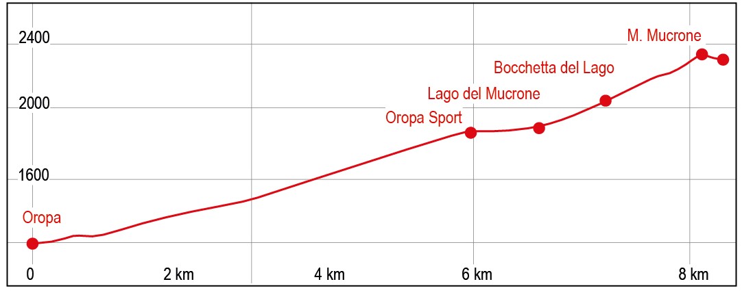
Monte Mucrone
Trail marker:
D24 – D13 - GTA
Place of departure:
Parcheggio Santuario di Oropa
Place of arrival:
Monte Mucrone
Departure altitude:
1300 m
Arrival altitude:
2335 m
Duration:
3 ore per la salita – 5 ore per la gita completa
Uphill height difference:
1000 m
Type of excursion:
Family excursion, Trekking
Season:
Late spring/summer
Climb the mountain that is the symbol of the Biella area; admire the Sanctuary of Oropa from above and the embrace of Monviso and Adamello with the boundless flatlands.
Access and parking
From Biella, go up the state road 144 until you reach the Sanctuary of Oropa; once at the sanctuary, follow the signs for the cable car, where you can park.
Route
Park your car and walk to the Cappella del Roc chapel, clearly visible from the main road, near the cable car station and the Oropa botanical garden. Continue along the tarmac road and cross the Oropa stream. Immediately after the bridge, on the left you will find the GTA path, signposted. Take the path and follow it through a beautiful beech wood, always staying close to the Oropa stream. After about 10 minutes, you reach to trail D13, continue upstream towards the upper station of the cable car.
Shortly before crossing a small stream, you come to trail D14 to Monte Tovo, which you leave to the right. Continue along trail D13-GTA, leaving another trail on the right that leads to the Nito Staich ferrata route. The route continues with some asphalted stretches and a decidedly increasing gradient. In a short time, you cross Rio Trotta and take trail D13 that climbs to the right, leaving the track that continues instead crossing the Oropa stream and connecting to the ski slope on the other side. Be careful: it will be possible to reconnect with the downhill route at this point.
A short walk up a pastureland leads to Alpe della Pissa (1448m - 0.35 hours from Delubro).
The path, which is well paved and always clear, continues until it meets the track that goes up to Alpe Trotta and Bocchetta di Finestra (0.35 hours from Alpe della Pissa). Continue on the path in the direction of the cable car arrival station to reach the Rosazza refuge (1813m - 0.20 hours from the fork). After passing the buildings and still following the path, you will soon reach the Oropa Sport building complex (1870m - 0.10 hours from the Rosazza refuge - 1.40 hours from the start).
From the cable car arrival station, a clear and very wide path leads in about 10 minutes to Lake Mucrone, of glacial origin, from which the Oropa stream springs. Just before the lake is the cippo dei bersaglieri (Bersaglieri memorial stone), close to a water source. Take the path on the left to reach the lake.
From the lake, to continue, leave the lake on the left, towards the evident "Bocchetta del Lago" (small mouth of the lake), which can be reached along an easy and well-marked trail (2026 m, 0.20 hours from the lake). From here, you enter the Elvo Valley with its beautiful views over the plain and the slopes of Mount Mars. Leave the path to the Coda refuge on the right and take the path to the left, which points towards Monte Mucrone. The path climbs up a moderate slope, passing just below the arrival station of the Mucrone cable car, now abandoned, until it comes out on the crest just above the building, with a view of the sanctuary, the plain and the surrounding peaks. A little further on, the path leaves the ridgeline and continues to the summit, remaining on the side of the Elvo valley (0.25 hours from Bocchetta del Lago). At the summit, there is an obelisk, paved in Balma syenite (a typical ornamental stone quarried in Cervo Valley). The summit cross can be reached along an easy path and is located on an ancillary peak, lower than the summit but more visible from the plain.
The return journey takes place along the same route to Oropa sport, from here there are two alternatives for the return to the Sanctuary:
- Along the ascent route, passing the Rosazza refuge and Alpe la Pissa.
- Along the evident Busancano, ski slope that descends towards the cable car departure area. The track takes off just before the Savoia refuge and the Oropa Sport building complex. A wide track descends to the right towards the Oropa Sanctuary. Follow the track that crosses several small streams. Then arrive near Lago delle Bose, on the right. The track then continues downhill until it reaches a hairpin bend, at which a junction leads to the itinerary followed uphill, reconnecting near Alpe la Pissa. The Alpe and the Oropa stream are clearly visible from the fork.
References
Passeggiate sulle montagne del Biellese di Corrado Martiner Testa - Blu edizioni