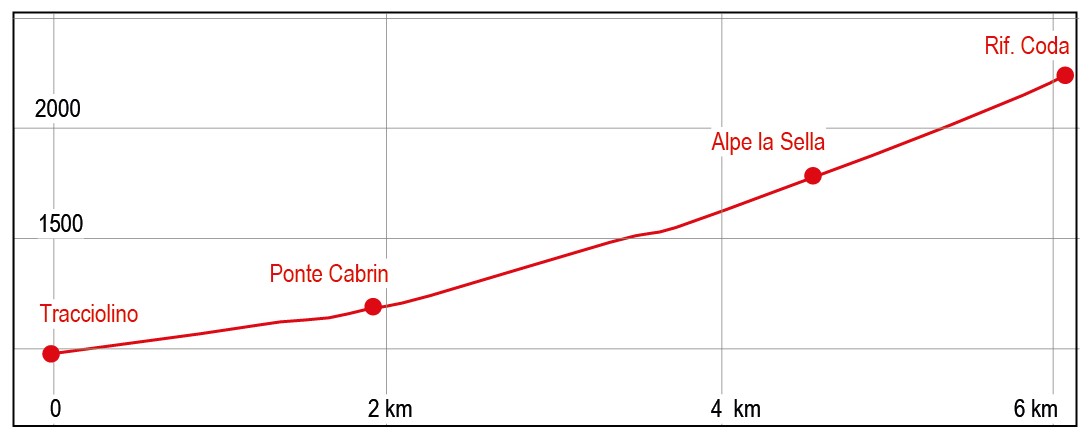
CODA REFUGE FROM CABRIN BRIDGE ON TRACCIOLINO
Trail marker:
C3
Place of departure:
Strada provinciale 512 in corrispondenza del ponte sul torrente Elvo
Place of arrival:
Rifugio Coda
Departure altitude:
970 m
Arrival altitude:
2303 m
Duration:
3.30 hours for the ascent, 6 hours for the whole trip
Uphill height difference:
1300 m
Type of excursion:
Trekking
Season:
Late spring/summer, Autumn
Discover a refuge rich in history between the Aosta Valley and the plain.
Access and parking
From Biella, reach Sordevolo. From here continue in the direction of Saint Grato and then towards the Antica locanda Le Piane, until you reach the provincial road 512 known as "Tracciolino". Turn left towards Andrate and follow the road until the bridge over the Elvo stream. A few metres ahead you can park your car. The itinerary starts just after the bridge on the left at visible gravel road with a bar and C3 trail marker.
Alternatively, you can reach Oropa Sanctuary via the S.P. 512.
Route
A few metres after the bridge over the Elvo torrent (950 m), the mule track begins. It passes by the Bossola and Raja di Graglia pastures (1138 m) and reaches Ponte Cabrin (1250 m) where it crosses the Elvo torrent. The path leaves on the left the crossroads for Colle della Lace, reaches uphill Alpe Le Piane 1310 m and after about 100 metres starts to climb towards the left leaving on the right the path towards Alpe Tura. It passes a hydroelectric cabin near the Arcomune Alp at 1568 m; then it crosses two streams. Continue over steep pastures to reach at 1831 m Alpe La Sella. Continuing on a marked bump, you pass near the ruins of a small alpine pasture with an excellent water source and from here in a few minutes, you get to the Refuge.
The entire route is well signposted, making it easy to find your way around.
Descent along the ascent route.
References
Passeggiate sulle montagne del Biellese di Corrado Martiner Testa - Blu edizioni