SELLE DI ROSAZZA AND MADONNA DELLA NEVE REFUGE
Trail marker:
E30 - E32 - GTA - E40
Place of departure:
Rosazza
Place of arrival:
Selle di Rosazza
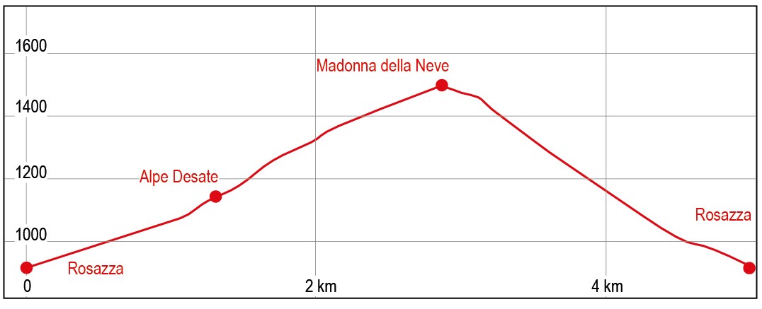
Departure altitude:
882 m
Arrival altitude:
1480 m
Duration:
1.40 hours for the ascent, 3 hours for the whole trip
Uphill height difference:
598 m
Type of excursion:
Family excursion, Trekking
Season:
Spring, Late spring/summer, Autumn
An easy trip to discover the Cervo Valley and its landscapes and history.
Access and parking
From Biella, go up the Cervo Valley along Provincial Road 100 to Rosazza. Past the church, take the road on the left (trail marker E30 to Colle della Gragliasca), which climbs up alongside a stream (Pragnetta stream) until you come to a widening where the road ends and you can park your car.
Route
Park the car and take the beautiful paved mule track (trail marker E-30 - E32) which runs at a low gradient parallel to the axis of the Pragnetta valley. Follow the path until clear signs for Sella and Desate invite you to turn right. The slope increases slightly and you gain height with a few bends. After about ten minutes, you will come in sight of the first houses in Desate. Once inside the village, pass by the small church and turn right, climbing up the narrow streets between the houses. Follow the abundant signs to leave the village, pass some ruined huts and start a first right-hand, low gradient traverse. After a hairpin bend, reverse direction and walk along a small ridge that you climb up, aiming directly at the line of the watershed ridge between the Pragnetta and Irogna valleys. The route tends to leave the ridge, turning left, and then it returns to gain height, turns right, cuts through a small valley and climbs up the next line of ridge, which you climb at a low gradient. In a short time, among the vegetation, the cluster of houses of the Vernetto alpine pasture comes into view. They can be reached by taking a low-slope traverse. Pass between the houses and in about ten minutes, with a final climb, you reach the Madonna della Neve hut. At the refuge, turn right and climb along the meadow to reach the small sanctuary building.
Descent along the ascent route.
References
Passeggiate sulle montagne del Biellese di Corrado Martiner Testa - Blu edizioni