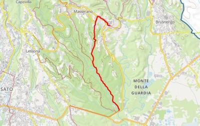
GTB Section 10: Castellengo - Brusnengo

Start: Castellengo, Church of Santi Pietro e Paolo (200 m)
Finish: Brusnengo, Forte di Brusnengo (345 m)
GtB legs: 34-38
Passing through: Castelletto Cervo (209 m) Terzoglio (225 m) Masserano (343 m)
Length: 24.1 km
Ascents and descents: 375 m (climb) 230 m (descent)
Time required: 8 hours
Difficulty: E - (Average - due to the length of the section)
Comments: After crossing the agricultural plain, you walk through the valley of the Torrent Ostola to the band of hills that surrounds Masserano, whose historic centre has retained its original layout.
Cross the road (the former SS232) and take a pleasant cart-track that cuts through the countryside towards the Church of San Vincenzo, which you will see from a distance. After passing the church, turn left towards a farmhouse, pass this and continue to the Torrent Cervo. When you come to a small paved road, cross the torrent and climb the opposite side towards Castelletto Cervo. Leave the road and cut down towards the Torrent Ostola which you follow, passing through an area of pools, before joining the SP313. Leave this road near the signpost at the start of Cossato and take the paved road to Lessona brickworks, which is now disused. Turn left onto a cattle-track that enters the wood in a northerly direction and continue to where it meets the Biella-Laghi main road. Having arrived at the SP230, leave the road for a cart-track on the left that will take you into a wood. A stretch through the hills will take you to the characteristic hamlet of Masserano, which you walk through, and then past the Church of San Teonesto. Descend to the Torrent Ostola, cross it and climb the other side to Rongio Superiore, from where you descend to Rongio Camillo. After crossing over the Torrent Bisignana, you walk along a stretch of the SP234 before climbing up towards the hamlet of Forte di Brusnengo on the left.
5 results


 SVincenzo chiesa (Mottalciata)_2.jpg/0ebaabbf-94c9-4ab5-829a-4f9b36cacb9c?t=1542097903234)
 Terzoglio (Castelletto Cervo)_2.jpg/5092d6ed-540a-4fd7-abb6-5d2222743124?t=1542097894430)
 Lessona_2.jpg/1032418d-fe4c-4221-9ba5-23db8b5958c0?t=1542097886788)

_2.jpg/9414c434-e056-4516-860a-2ef6ede9582e?t=1542097931339)