GTB Section 09: Cerreto Castello - Castellengo

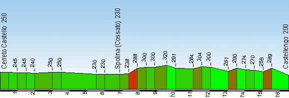
Start: Cerreto Castello (250 m)
Finish: Castellengo (Cossato) (200 m)
GtB legs: 31-33
Passing through: Spolina (Cossato) (233 m)
Length: 16.7 km
Ascents and descents: 210 m (climb) 260 m (descent)
Time required: 5’40”
Difficulty: T - (Easy)
Comments: The Baragge, which you cross around Castellengo, are extensive grasslands with the occasional oak tree. The scenery is more akin to the African savannah than northern Italy.
After following various paved roads and carttracks, at Cascine Ronco you once more take the paved road on the left that ends at what used to be the SS232. Considering the busy traffic, it is best if you take the bus to Castellengo. Once there you climb up to the castle. From the Baragge Ecomuseum, you turn right and follow a maze of cart-tracks and paths through the woods till you come out near Cascina Pescia. You come to a paved road that will take you to a parking area where you enter the Baraggia di Candelo. After admiring the open grassland (above), you will descend into a small valley and reach the Candelo road. Leave the road just before a bend to the right, enter a thick wood and descend into the Valle Fresca, following the stream. Cross this and on the other side follow a not particularly visible track that runs next to a drainage course. When you reach the dirt road that runs past Cascina Bonino, take the paved road down to a small bridge where you will see a cattle- track on the right. Follow this track into the wood, cross the Bonda Grande and climb the opposite side along a cart-track that leads to Canton Stellino. From here a path heads into the wood on the left and takes you to a paved road that leads to the Church of Santi Pietro e Paolo.
3 results


_2.jpg/4272ff1a-1081-4ae7-9f93-c9ce46250155?t=1542097890466)
 Baraggia di Candelo_2.jpg/4ba30129-f0ea-4089-a495-cb18a507b298?t=1542097907379)
_2.jpg/e3ea25ad-40d7-4170-b9d4-4d4359ba6cd2?t=1542097882947)